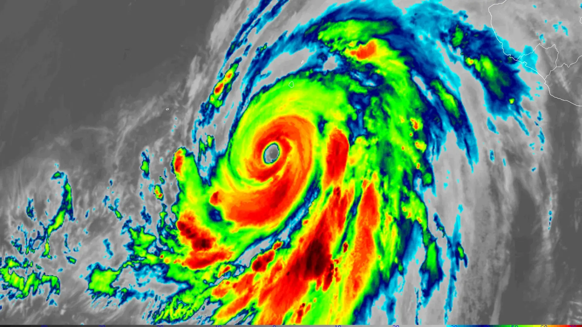
A significant weather event is unfolding as Category 4 Hurricane Hilary sets its course for Southern California, marking the potential for the region’s first direct tropical storm hit since 1939.
Here’s the latest update on Hurricane Hilary’s trajectory:
- A tropical storm watch is now active along the California/Mexico border to the Orange County-Los Angeles County Line and Catalina Island. This serves as a remarkable and rare weather alert for this part of the country.
- As of Friday, 11 am ET, Hurricane Hilary is classified as a formidable Category 4 storm, boasting peak winds clocking in at 145 miles per hour. Its center is approximately 360 miles south-southwest of Cabo San Lucas, Mexico, with a northwestward movement at 10 mph.
- Projections anticipate an abrupt turn northward and an acceleration in forward speed within the next 24-36 hours.
- Although the hurricane is forecasted to weaken as it traverses cooler ocean waters on Saturday, the quicker forward movement could limit the extent of this weakening.
The threat posed by Hurricane Hilary encompasses a set of unprecedented weather patterns, attributed in part to human-induced climate change, that are propelling the weakened storm northward into the typically arid Southwest over the next few days.
Key points to note:
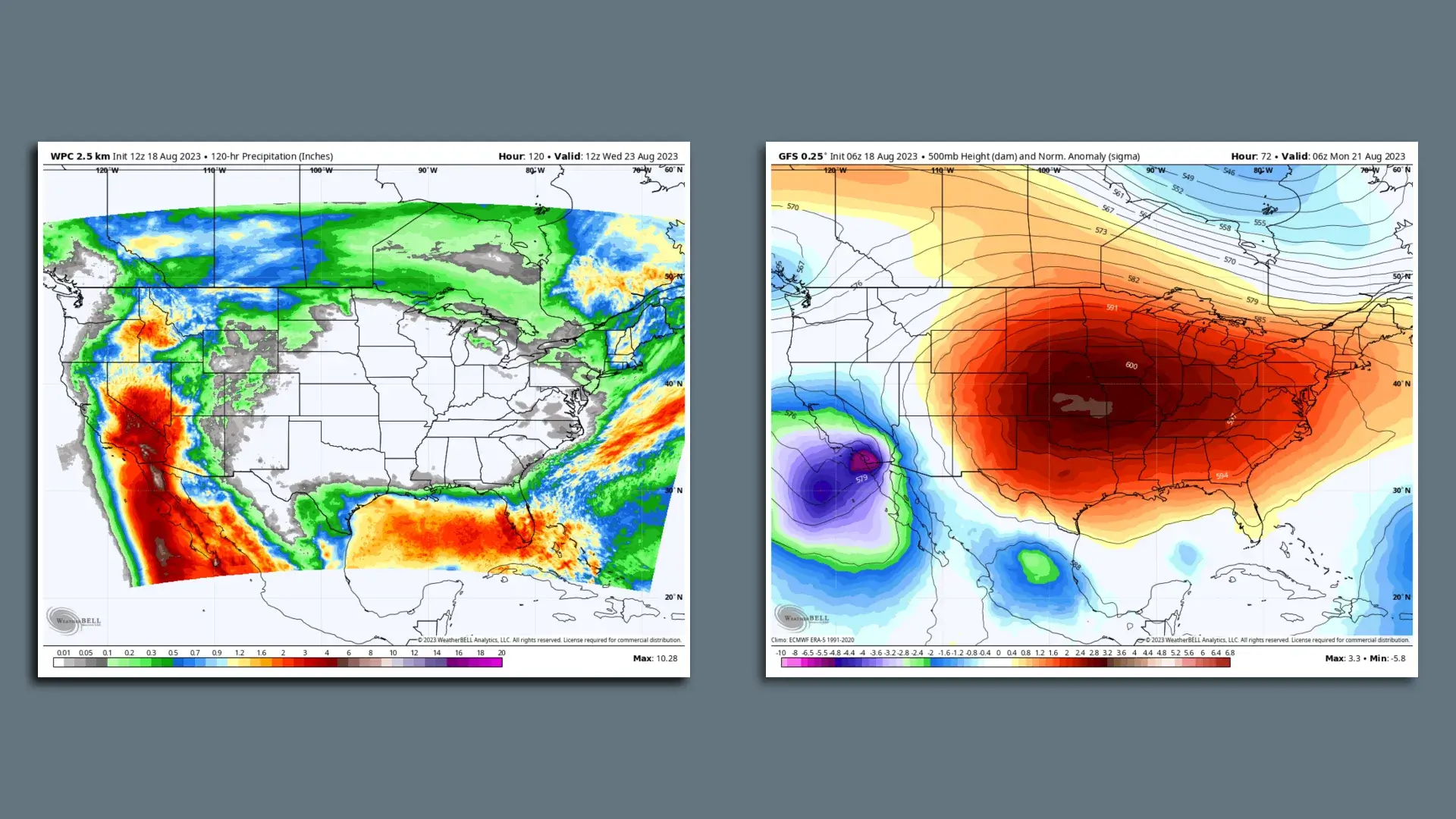
- An elevated risk of heavy rains, high winds, and potential beach erosion is emerging from San Diego to Los Angeles. This threat will extend inland across eastern California’s deserts, peaking on Sunday and Monday.
- The National Hurricane Center underscores the potential for “rare and dangerous flooding,” along with tropical-storm-force winds as the hurricane approaches southern California.
- With the convergence of heavy rainfall, flash flood potential, and strong winds, the National Weather Service in San Diego stresses the high-impact nature of this event for Southern California.
- The Weather Prediction Center has identified areas from San Diego to Las Vegas under a “moderate risk” for excessive rainfall. Particularly notable is the first-ever “high risk” for low-elevation sections of San Diego County, where warm, moist air will ascend, cool, and release substantial rainfall.
Human-caused climate change is linked to an increase in extreme precipitation events, intensifying the effects of tropical storms and hurricanes, leading to heightened rainfall due to warmer atmospheric and oceanic conditions.
By the numbers:
- The forecast from the National Weather Service projects rainfall ranging from 2 to 10 inches across Southern California and neighboring states.
- Flash flood watches are active for about 26 million people across California, Utah, Nevada, and Arizona.
- Hurricane Hilary experienced an extraordinary surge in maximum sustained winds, growing by 80 mph within a mere 24 hours – a rate surpassing the threshold for rapid intensification.
- Notably, recent years have seen a trend toward more frequent and rapid intensification of hurricanes and typhoons, a phenomenon associated with climate change.
The Larger Context:
- The exceptional weather dynamics driving Hurricane Hilary into the Southwest include a robust and expanding heat dome across the Central U.S. This intensified heat dome is likely amplified by climate change, influencing an exceptionally hot week for millions across Texas to Iowa.
- This heat dome, combined with other weather systems in the eastern Pacific, will propel Hurricane Hilary unusually quickly northward, deviating from the typical pace of tropical cyclones in that region.
In this unique scenario, Hurricane Hilary may arrive in Southern California before fully dissipating over cooler waters. The convergence of various factors underscores the complexity of weather patterns in a changing climate landscape.